The Siurana Traverse
After five days on foot and a little over 90 km, on 31 March we reached the confluence of the Siurana river with the Ebro. It was the end of the walk that marked the beginning of The Open Shore, a project that addresses the diversion of the river’s water to Riudecanyes as a territorial and symbolic wound.
The Siurana is a short river, but with a very distinct character: from the canyon and escarpments of the Prades Mountains (Priorat, Catalonia, Spain) to the Ebro valley (Ribera d’Ebre), the territory it crosses is highly varied in both geology and landscape.
Celeste and I were never alone on the walk, enjoying quiet spring days (no rain, no heat, an exception in recent years) and a river carrying unusually high water. It was an exceptional abundance, due to the months of rain this past winter: the Siurana usually carries little water, with its flow permanently diverted to another basin.
Walkers: Marco, Celeste, William, Eliseu, Mònica, Roser, Joan. Accomplices: Montserrat (Terra d’Art); Joana and Rubio; Priorat Dibuixa; Mas de Sant Marcell winery; Anaïs, Lluís and Anna (Plataforma pel Riu Siurana); Arnau, Isabel and Auró (El Petit Llop); Pilar and Josep (Ca La Pubilla), Fundació Quim Soler; Oriol, Quim and Antònia.
- Project and credits: The Open Shore
- The Siurana: Anatomy of an Extraction
- Photographic record (under construction)
27.03.2026 · Day 1: La Febró > Siurana
Headwaters of the Siurana river (La Febró, 27.03.2026)
Spring is slow to arrive. The mornings are still cold and the light is the dry, muted light of winter. We are in La Febró, a small village of second homes in the Prades Mountains.
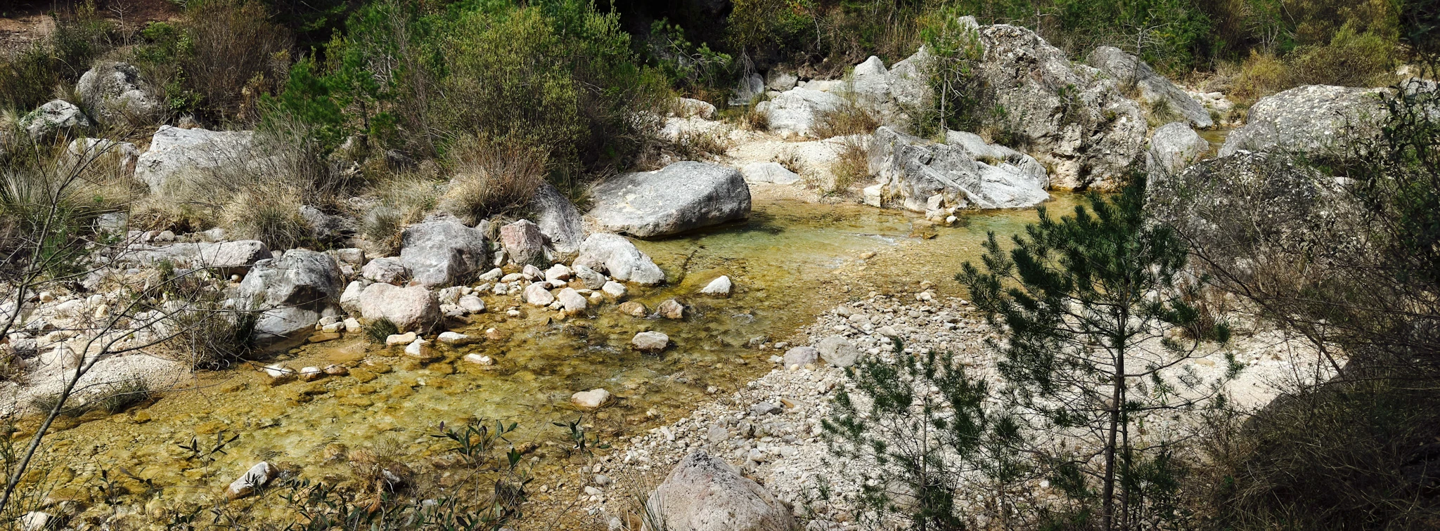
The route begins at the headwaters of the Siurana, in a landscape where the river is still young, narrow, and boxed in between rock walls. The Siurana has no single spring; it is born as the confluence of several ravines (among them the Foradada ravine, the Cova del Corral ravine, and the Avellanar ravine) on the outskirts of the village. In this stretch, over geological time, water has carved its way through limestones1 and dolomites2, opening caves, pools, and a karst canyon3. The crystal-clear waters of the Siurana flow through the cracks of time, separating the rocks of the Paleozoic basement to the north from the Mesozoic cover to the south. It is the most abrupt and foundational stretch of the journey: rocks, enclosed walls, and the sense that the river is still carving out its own body.
The day ends with the climb to Tossal del Prior, in Siurana, overlooking its reservoir. The ascent reveals itself slowly between two rock walls, so vertical that it is impossible to guess where the path goes. You have to trust the path, step by step.
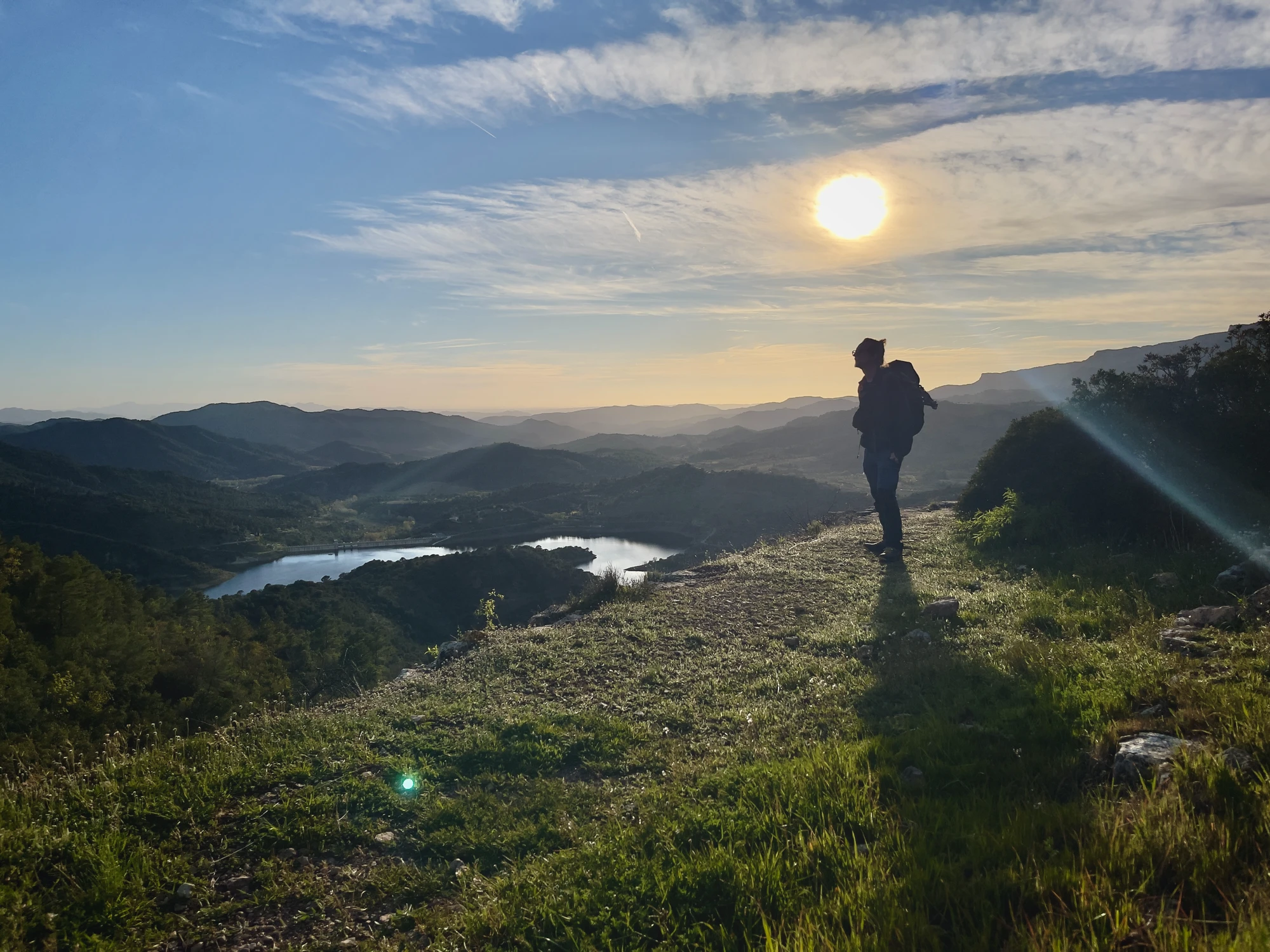
The Siurana reservoir. Photo: Celeste Reyna.
28.03.2026 · Day 2: Siurana > Poboleda
From Siurana to Poboleda, the landscape begins to change: we enter the Priorat of llicorella4, the dark, laminated rock that marks much of the comarca’s physical character. It is a very clear day of transition: from the more spectacular relief of the rock walls to a territory where the river also begins to be read as a regulated, intervened, and disputed space.
Leaving behind the enclosed walls of the previous day, we move through more open spaces, climbing gentle hills and crossing riparian woodland. About ten kilometres southwest of Siurana lies the assut of the Venta del Pubill. At this point, the Riudecanyes tunnel opens, the open shore that diverts four fifths of the Siurana towards Reus. This is the place around which the conflict shaking the Priorat unfolds, and for that reason it is the community meeting point of this traverse. Here we met with the Priorat Dibuixa community to collectively portray the river’s wound. Anaïs Estrems, from the Plataforma pel Riu Siurana, also joined us and informed us about the struggle against the plunder of the river and the current legal case. The event closed with a visit to Mas de Sant Marcell winery5, accomplice and host.
We spent the night in Poboleda, sheltered at the Estrems house. We are in the centre of the historic Priorat, where the Carthusian memory and the trace of the winegrowing splendour of the eighteenth and nineteenth centuries still live on.
29.03.2026 · Day 3: Poboleda > Torroja > Gratallops
From Poboleda to Gratallops, the Siurana enters fully into the heart of the Priorat. Cultivated plots multiply and fluvial terraces6 appear. The valley remains narrow, and with the river so swollen, the stretch between Poboleda and Torroja is completely flooded. The river is now the path. It takes us more than five hours to cover 5 km, almost all of them in the water, looking for traces of the original paths. There is no trace of human passage; the paths are overrun by undergrowth. Feet reddened by the cold water, ankles and calves scratched by the invisible grazing of Clematis flammula (vidiella). There are no bridges, because they were never needed. Within this abundance, the systemic lack of water becomes more evident: the tracks and paths are flooded because they were created around a river that usually suffers long periods of low water7. Here, water is the exception.
In Gratallops we received a warm welcome and were lovingly hosted at the home of the Little Wolf. The place name Gratallops tends to draw attention, so it is worth pausing on it for a moment. According to the etymological hypothesis now most widely used in official Catalan toponymy8, the name would be formed from grata —perhaps the result of a folk-etymology substitution for glata, derived from glatir (‘to howl’)— and llops. Another hypothesis9, however, proposes an Arabic origin: garāt al-āws, meaning “the caves of the wolf”.
30.03.2026 · Day 4: Gratallops > Bellmunt > El Masroig
From Gratallops towards Bellmunt and then El Masroig, the route enters the old mining basin of the Priorat, where the landscape no longer speaks only of vineyards and river valleys, but also of underground extraction. In Bellmunt and its surroundings, the most visible trace is lead mining, extracted from galena10, with spoil heaps, facilities, and galleries that still make the industrial dimension of the subsoil visible. The Priorat has a long mining tradition: there is evidence of metal trade in the El Molar-Bellmunt-Falset area during the eighth and seventh centuries BCE, in exchanges with the Phoenicians, who brought wine and took away lead and silver.
Past the mines, from Bellmunt to El Masroig, the red-earth track rises gently through the Mediterranean woodland. El Masroig, the mas roig. The day is warm and the clayey path shines a vivid red.
31.03.2026 · Day 5: El Masroig > Aiguabarreig > Garcia > El Molar
From El Masroig to Garcia, the river enters its final stretch and the landscape opens towards the Ebro valley. The Paleozoic11 and Mesozoic12 mountains of Prades fall behind, at a distance of several tens of millions of years13. Here the landscape widens, generously, and the river spreads over a gravel bed. Accompanied by Joan and Roser, we walk through the valley looking at the old dry-stone walls raised on the heights, sheltered from floods. Joan knows the Priorat as his home; he is one of those human intelligences made of experience, curiosity, and love for his land. Qualities he shares with Roser, whose way of seeing is also deeply rooted in the territory, its memory, and its language.
The Siurana reaches the Ebro carrying rock, erosion, memory, and conflict with it. Downstream from the Mequinensa, Riba-roja, and Flix reservoirs, it could be the first and only river contributing sediment to the delta14 — and this spring, it is. But plundered and diverted out of its basin, it usually arrives emptied of matter and memory, extending its wound all the way to the sea.
The aiguabarreig is stirred by the wind. The blue-green waters of the Siurana mix with the ochre-tinted waters of the Ebro. “The cleanest water is the Siurana’s,” Roser says, smiling.
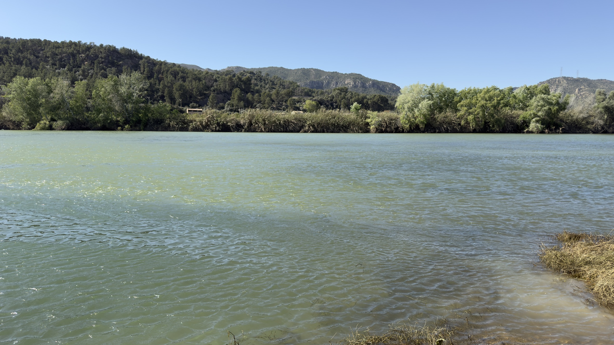
The Ebro-Siurana aiguabarreig.
-
Limestone: sedimentary rock composed mainly of calcium carbonate. ⤶
-
Dolomite: carbonate rock composed mainly of dolomite, a calcium magnesium carbonate mineral. ⤶
-
Karst canyon: a narrow, deep valley carved by water into soluble rocks, especially limestones and dolomites, within a karst system. See El canó càrstic del cingle de la cova Serena. ⤶
-
Llicorella: the local Priorat name for Paleozoic slates and phyllites, dark, laminated, fissile rocks that are highly characteristic of the Priorat. See Parc Natural de la Serra de Montsant, geology section: Geologia. ⤶
-
Sant Marcell was a small enclave of the Priorat already mentioned in 1180, probably formed around a chapel; by the mid-thirteenth century it had at least a mill and four farmsteads (Enciclopèdia Catalana, “El marc històric del romànic del Priorat”). According to its current owners, local tradition holds that the monks of Escaladei went down there to die. ⤶
-
Fluvial terrace: a flat, bench-like structure that marks a former position of the river, abandoned when the channel cut down to a lower level. ⤶
-
Low-water period: the lowest level or minimum flow a river reaches in the dry season; the term also refers to the period when this occurs. See Real Academia Española, Diccionario de la lengua española: estiaje. ⤶
-
Nomenclàtor oficial de toponímia major de Catalunya, entry Gratallops: “Documentat al segle XV, compost pel mot grata, derivat de gratar, el qual potser va substituir per etimologia popular la forma glata, que és un derivat de glatir ‘udolar’, i pel mot llops.” See also the municipal Gratallops record with the same entry: Gratallops — Nomenclàtor oficial. ⤶
-
Hypothesis defended by Pere Balañà and cited by Dolors Bramon in “Homophonic transformation of toponyms: some examples from Andalusi Arabic and a new instance from Pla de l’Estany”, where she states that Gratallops derives from garāt al-āws, “the caves of the wolf”. ⤶
-
Galena: lead ore that was the main object of exploitation in the Bellmunt del Priorat mines. In the context of the Priorat mining basin, galena is the mineral from which lead was obtained and is one of the keys to understanding the area’s extractive history. See Museu de les mines de Bellmunt del Priorat and Primeros datos arqueométricos sobre la metalurgia del poblado y necrópolis de Calvari del Molar. ⤶
-
The Paleozoic rocks of Prades formed between 541 and 252 million years ago, before the appearance of dinosaurs. ⤶
-
The Mesozoic rocks, between 252 and 66 million years ago, belong to the time of the great inland seas that left the limestones of the south. ⤶
-
The final stretch of the Siurana runs through the Móra basin, a depression filled during the Cenozoic (between 66 and 23 million years ago) and more recently covered by Quaternary deposits — fluvial terraces and alluvium from the last 2.5 million years — that shape the valley’s current landscape. ⤶
-
The Canaletes, the other tributary downstream from the large reservoirs, is a river with marginal flow whose sediment contribution to the delta is negligible. The Siurana would be the only one with real capacity to contribute sediment. ⤶